VALRPAS Data Processing Partner Caslys

Caslys Consulting

Established in 2005, Caslys Consulting Ltd. is a geospatial consulting company specializing in Remote Sensing and Landscape Analytics, Geographic Information Systems (GIS) and information management services for the environmental and natural resources management industries, with over a decade of experience working with agriculture data.

Why use Caslys for Data Processing?

  • Experienced geomatics professionals generating and reviewing your data.
  • Tools, experience, and skills for large and complex datasets such as multispectral imagery, LiDAR, and point cloud data.
  • Save time, money, and effort on a wide range of data products with Caslys’ information-based approach to your crops.

Crop Health Monitoring
Advanced crop health monitoring solutions give you a bird’s-eye view of your fields, empowering smarter decisions. High-resolution imagery reveals how crops are growing, highlights areas of stress, and detects early signs of pests, diseases, and drought stress. With these insights, you can act quickly to maximize yields, reduce costs, and save time on costly fixes. Multi-spectral analysis offers a powerful way to ensure your crops stay healthy and are highly productive. Elevate your approach to farming and see your farm like never before.
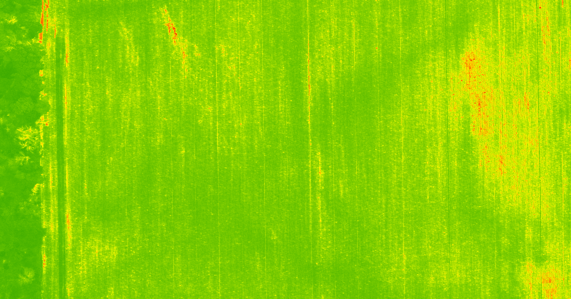
This crop health map is derived from the near-infrared and red bands of a multispectral image. Red-shaded regions represent lower values, indicating potential issues such as poor crop heath, stress or sparse vegetation. In contrast, green-shaded regions show higher values, meaning the crop is healthy and growing well.
Superior Performance and Versatility

Pest and Weed Control

Caslys Consulting provides innovative pest and weed management solutions designed to help you take control of your fields with precision. Using high-resolution imagery, we accurately identify areas affected by weeds or pests, enabling targeted prescriptions that save resources and reduce overuse of treatments. By addressing these issues early, you can protect crop health, improve yields, and maintain sustainable farming practices. Our approaches ensure efficient, cost-effective management, while also minimizing environmental impact. Take a proactive step toward healthier, more productive fields with our services.
Superior Performance and Versatility

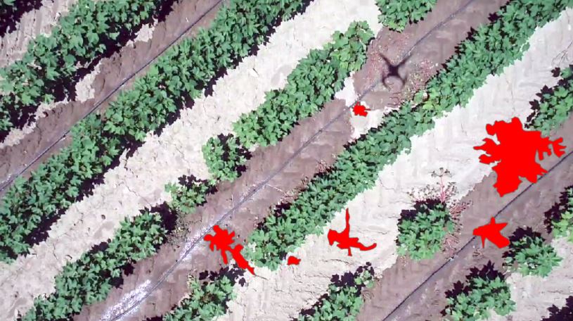
This map highlights early weed growth (shaded in red) within crop fields. These are generated automatically through computer classification.

Nutrient Mapping for Fertilizer Optimization

Enhance your fertilizer strategy with our nutrient mapping service. By analyzing high-resolution multispectral imagery, we create detailed maps that reveal nutrient variability across your fields. These insights empower you to fine-tune your fertilizer application. With precise nutrient mapping, you can improve crop health, boost yields, and reduce costs. Take the guesswork out of fertilizer planning and make data-driven decisions to maximize your farm’s potential.

Optimized Irrigation Management

We combine advanced remote sensing techniques, including thermal and multispectral imaging, to deliver a detailed assessment of canopy water of your crop. These insights can help pinpoint areas under stress, enabling precise and efficient irrigation planning. This approach enhances crop health and maximizes yields, while also promoting sustainable water resource management.
Field Zoning

Field Zoning

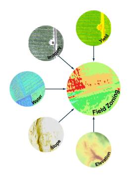
Optimize your farming operations with Caslys Consulting’s Field Zoning service. By analyzing high-resolution imagery with a variety of other data sources, this analysis divides fields into distinct zones based on factors such as soil health, crop performance, and nutrient variability. These zones enable you to tailor your farming practices to the specific needs of each area. With precise field zoning, you can improve efficiency, reduce waste, and boost yields, making every part of your field work smarter.

Crop Damage Assessment

We provide accurate and timely evaluations of crop losses caused by events such as hailstorms, drought, or other natural hazards. Using high-resolution imagery and advanced remote sensing techniques, we analyze key indicators of damage, such as changes in vegetation health, canopy structure, and biomass. Our detailed damage maps help you quantify the impact on your fields and identify the most affected areas. Whether you need data for insurance claims, replanting decisions, or long-term planning, our service delivers actionable insights to support your farm’s resilience and recovery.

Yield Trend Analysis

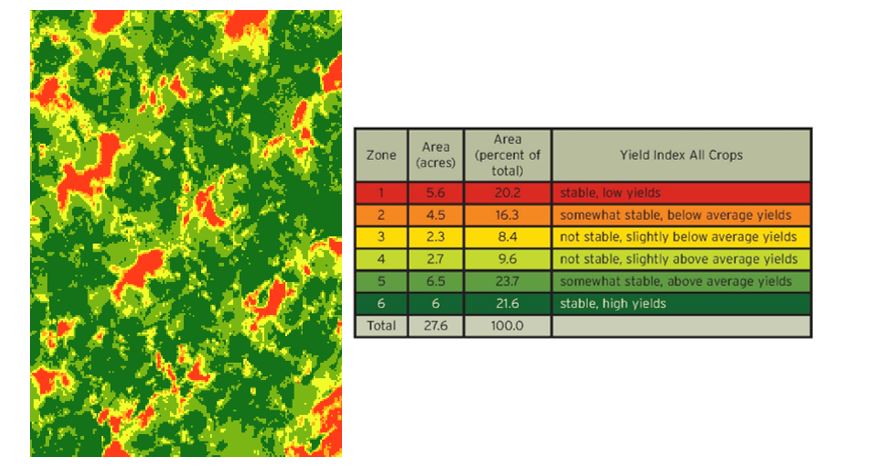
Our Yield Trend Analysis services help farmers optimize their crop productivity and make data-driven decisions. Using imagery captured throughout the season, we assess how crop yields change, identifying areas with high and low productivity. This analysis can also be done over the years to find long-term yield trends. Our insight into yield patterns helps you to focus resources where they are needed, saving time and reducing waste. Yield data can also be combined with weather patterns, soil health, and crop health data to provide a comprehensive understanding of what is influencing your crop productivity.
Yield Trend Analysis

Contact Us For a Request a Quote